Horse As Teacher, The Path to Relationship is now available for purchase. Click here for details!
 |
GOLDEN EARS NATIONAL PARK: Riding the East Canyon Trail
(Photos at the botton of this article)
Location: Coast Mountains 11 km north of Maple Ridge on the north side of the Fraser River. Follow park signs north from Hwy 7. About 48m east of Vancouver going up the Fraser Valley. The nearest center is Maple Ridge B.C.
Size: The size of the park is 55,590 Hectares
History – The park was named after the twin peaks of Mount Blanshard near the peak’s western boundary. Originally part of Garibaldi Provincial Park, the establishment of Golden Ears Park in 1927 recognized the almost impenetrable mountain barrier between the two areas.
Cultural Heritage – Human activity in Golden Ears, both past and present, has been confined to the accessible Alouette Valley in the south of the park. In the 1920s, the forested slopes of the valley became the site of BC’s greatest railroad logging operation until a disastrous fire swept through the valley in 1931. The lake and its forested surroundings were also the traditional hunting and fishing grounds for the Douglas-Lillooet (Interior Salish) and Katzie (Coast Salish) First Nations peoples.
Conservation – The park represents the Coastal Western Hemlock biogeoclimatic zone and is characterized by a second-growth forest of western hemlock, western red cedar and Douglas fir. There are a series of sphagnum bogs at the south end of Alouette Lake.
Wildlife – The park’s lush plant growth, numerous waterways, and mountainous terrain provide habitat to a variety of animals including beaver, deer, black bear, and mountain goat.
HORSE TRAILS!
Mensies Trail – 9km, easy. This is a multi-use trail of horse/hike/bike. There is very little elevation change, making it an easy hride of about 2 to 4 hours.
Mike Lake Trail – 4.2 km, easy. This is a horse/hiking trail that takes you to Main Corral. It’s an easy trail that should take you about 2hours and has an elevation change of about 100 meters.
Incline Trail – 1.2km, moderate. The trail is a steep horse/hiking trail that takes you to Mike Lake. It should take about 1 hour and has an elevation change of 150 meters.
East Canyon Trail- 5km to the backcountry horse camp & the River, but the trail does continue north for many, many more kms. Camping with horses is permitted in the designated camping area on the East Canyon Trail, approximately 5km north of Gold Creek parking lot.
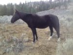
I had ridden the East Canyon trail a couple times now. What I really love about this trail, is that you end up at the river where you can cool your horses off, give them a drink, have a swim and then settle them under the trees while you have a picnic lunch in the shade.
The views are fantastic, with the river rushing by. There are lots of trees to high-line your horses, plus there is the old horse camp site, should you want to stay the night. There is even a little outhouse!
Trail Map: Allouette Lake Trails
Take a look at my photos from my ride there about a week ago (18 August 2010): Click on the photos to see them in full size.


Click here to get your free gift!
Privacy Policy:Your email address will never be sold, rented, or given away.